These small video clips, which I took July 27 give an indication of the extent of change to the soil and pools of water that were found. Half a month later, it still looks the same.
The first clip is walking east along the path at the south side of the landfill towards the leachate area, panning around the leachate area.
The second clip shows a close up of the oily sheen on the surface of the water at the leachate location, and the water visibly flowing over the steep cliff to the south, where it flows towards Harmony Creek (and Lake Ontario).
August 19, 2008

August 17, 2008
Sample results are in - and do not look good
The following samples were taken at the leachate location during multiple visits and were graciously paid for by the Lake Ontario Waterkeeper, a grassroots environmental group in Toronto. The show levels of heavy metals at the landfill in the soil in June and July. (Click on the image for a larger view)

Looking at this data in comparison to provincial and federal water quality guidelines, some of the levels seem very high – I have bolded the contaminants which are over the guidelines and listed in the last column how many times are exceed the limit. For example, Cadmium – a known carcinogen found in some industrial paints and manufacture of some batteries. – exceeds the Canadian Water Quality Guidelines for the Protection of Aquatic Life limit of 0.017 ug/L by 88 times.
While the levels of some of these contaminants in water are very concerning, comparing the soil samples has been more difficult and I am currently seeking people knowledgeable in this area to help understand this data. More samples were taken recently at the landfill and following the wetland to the outlet in order to assess whether the wetland (to the south of the landfill) is filtering out these contaminants. Below are some pictures from the most recent sampling I performed.


Now that there is data backing up the threat of this landfill to humans and the environment – and more pending – there is greater evidence to demand action. Government and City officials do not seem to care enough to bother, and it seems a greater profile needs to be raised. It is time to get the community involved, and I am taking steps towards this. Please contact me at harmonylandfill@gmail.com if you know anything about the history of this site or are interested in getting involved in any regard.
July 27, 2008
Absolute Chaos
I thought that with all the heavy rains Oshawa has been receiving lately, that perhaps the rusty substance would have returned to the surface of the site. I was absolutely blown away because the site is almost unrecognizable!
Yes, there has been a lot of rain, but I highly doubt they could have caused this much change. All of the vegetation that had grown over much of the area is no longer there and both monitoring stations have vanished - leaving nothing but dirt, gravel and pools of rusty and oily water.This looks like the work of something - or someone.

The former locations of the white and blue monitoring stations can be seen in these pictures.
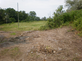

The rusty coloured substance can be seen flowing all the way down the path, almost to the manhole cover on the south-west side of the property.


Most concerning of all is the oily sheen on the top of numerous areas of water. It is very evident and shows up well in the pictures below, which were taken in various areas. In the last picture, the surface water was carrying this substance down the steep drop to the south of the landfill towards the river. Whatever it is, this substance is clearly being carried into the adjacent creek.


This picture was taken facing east with the old leachate area in the foreground and an overview of where the water is currently flowing. (click on the picture for a larger image)

Something needs to be done immediately to determine that whatever this oily substance is does not pose a threat to the health of humans and species in the nearby creek! If this site were merely 'iron staining', what is this oily substance doing along with it? Is it coming from the landfill? What is it composed of? Whatever it is, it should not be permitted to flow into the environment without monitoring to ensure it is safe.
A sales centre has recently been built on the corner of Grandview Street and Rossland Street. The last picture is full of irony with the sales centre in the foreground advertising "These woods were make for walking" and the landfill in the background. Not to mention the subdivision adjacent to it.


Yes, there has been a lot of rain, but I highly doubt they could have caused this much change. All of the vegetation that had grown over much of the area is no longer there and both monitoring stations have vanished - leaving nothing but dirt, gravel and pools of rusty and oily water.This looks like the work of something - or someone.

The former locations of the white and blue monitoring stations can be seen in these pictures.


The rusty coloured substance can be seen flowing all the way down the path, almost to the manhole cover on the south-west side of the property.


Most concerning of all is the oily sheen on the top of numerous areas of water. It is very evident and shows up well in the pictures below, which were taken in various areas. In the last picture, the surface water was carrying this substance down the steep drop to the south of the landfill towards the river. Whatever it is, this substance is clearly being carried into the adjacent creek.


This picture was taken facing east with the old leachate area in the foreground and an overview of where the water is currently flowing. (click on the picture for a larger image)

Something needs to be done immediately to determine that whatever this oily substance is does not pose a threat to the health of humans and species in the nearby creek! If this site were merely 'iron staining', what is this oily substance doing along with it? Is it coming from the landfill? What is it composed of? Whatever it is, it should not be permitted to flow into the environment without monitoring to ensure it is safe.
A sales centre has recently been built on the corner of Grandview Street and Rossland Street. The last picture is full of irony with the sales centre in the foreground advertising "These woods were make for walking" and the landfill in the background. Not to mention the subdivision adjacent to it.


June 25, 2008
Development Services Committee meeting - June 9
I have copied the minutes from the Development Services Committee meeting I attended on June 9th. I was assured that I would be informed as soon as the City received news, but have not yet heard anything. An e-mail sent June 10th to two employees at the Central Lake Ontario Conservation Authority regarding where, when and what kind of monitoring will be performed by them at the landfill received no reply. So right now I am in a waiting game, but am not giving up!
Development Services Committee Minutes - June 9, 2008
(Available on the City of Oshawa's website)
Sarah Ross – Requesting to Address Committee Regarding Leachate at Harmony Creek Landfill (All Wards)
The Committee reviewed Correspondence DS-08-238 dated June 4, 2008 from Sarah Ross expressing concern about the leachate at the Harmony Creek landfill.
Sarah Ross addressed Committee regarding her concerns about the leachate and possible heavy metals at the Harmony Creek Landfill advising that she has contacted the local conservation authorities and the Ministry of Environment regarding this issue and has been advised that there has been no monitoring of this location since the early 1990’s. Sarah Ross noted that the trails are widely used by the public and should be investigated to ensure public health and safety.
The Committee questioned the delegation.
The Committee questioned the Commissioner of Development Services.
Moved by Councillor Nicholson,
"That Correspondence DS-08-238 dated June 4, 2008 from Sarah Ross expressing concern about the leachate at the Harmony Creek Landfill be referred to staff to obtain an update from the Ministry of Environment and to work with other agencies, including the Central Lake Ontario Conservation Authority, and to report back to Committee and that Ms. Ross be advised of the results." CARRIED
June 16, 2008
More visuals
Unfortunately I do not have a whole lot to report. Some time in the last little while, one of the monitoring stations near the leachate has been tampered with. By the looks of it, the hinges were taken apart because the lock is still in place and secure.


Walking to the South East of the landfill, I noticed an oily sheen on the surface of a small pool of water. It was hard to capture on camera, but definitely visible to the eye. This area is located adjacent to the landfill and approximately 100 metres north of Harmony Creek, with clear erosion from the flow of water during high run-off. A small river can bee seen flowing near this pool along the side of the path into the Creek.


Walking to the South East of the landfill, I noticed an oily sheen on the surface of a small pool of water. It was hard to capture on camera, but definitely visible to the eye. This area is located adjacent to the landfill and approximately 100 metres north of Harmony Creek, with clear erosion from the flow of water during high run-off. A small river can bee seen flowing near this pool along the side of the path into the Creek.


June 13, 2008
"Not the right time to sell"
It turns out the sale of the property I posted yesterday has been terminated.
I spoke to the real estate agent to see if I could see the Landfill Summary Report from 2002, however he told me the owner is taking it off the market, and that the owner said it "isn't the right time for it to be up for sale".
Unfortunately, the owner took back all the documents, so the agent did not have them any more. However, the Landfill Summary Report must be in the hands of another person. I will continue in my search to uncover more information on the landfill site.
June 12, 2008
Vacant land(fill) for sale!
I have discovered that a rectangular piece of vacant land has been listed for sale at the corner of Rossland and Grandview - keep reading, it gets better! This encompasses 20 acres of the Harmony Creek landfill and 50 acres to the south. This is pretty shocking stuff, because I am fairly certain that this area encompasses the leachate area!
Real Estate Type: Vacant Land
Land Size: 70.00 Acre
Location: Rossland Rd, Oshawa, ON
Price: $4,900,000
The "General Description" in the listing spells out the details of the landfill:
This 70 Acre Rectangular-Shaped Parcel Of Land Is Dissected North From South Into 2 Portions By The Future Rossland Road Eextension. There Is An Approximate 20 Acre Former Landfill Footprint In The North-Western Portion Of The Lot. No Landifll Waste Was Deposited Since June 30, 1980. The Approximate Southern 50 Acre Portion Is Undeveloped Land With Some Groundwater Flow To Harmony Creek. This Property Is Surrounded By Many Large Modern Subdivision Homes.**** EXTRAS **** There Was A Certificate Of Approval To Operate An Industrial Landfill On The 20 Acre Site. Listing Broker Has A May 2003 Rossland Road Environmental Assessment Report And A 2002 Landfill Site Summary Report.
Who would want to buy this property I have no idea, but but chances are it would be for development. I am thinking this 2002 Landfill Site Summary Report must be publically accessible so I will try to track it down.
The picture listed with the property faces East at the intersection of Rossland Road and Grandview Street, where many people park their car and walk along the South side of the landfill. The lecahate is literally a 1 minute walk east from here - if that.
Subscribe to:
Posts (Atom)
